Safely airborne (well, relatively safely) I extract the seat cushion from my clenched butt cheeks and we climb away from Louisville into the brightening early morning skies to the east.

With the immediate after take-off items complete (flaps, gear, etc.,) I turn to a 110 degree heading to intercept J78 to HVQ. The airspeed hold is set to 250 knots below 10-thousand and the EHSI is showing a TCAS target ahead 1200 feet below us. The LD767 also incorporates the green altitude predictor arc in front of the aircraft which predicts the point at which you will level off at the pre-selected altitude at the present climb rate. The green dot on the course line indicates the FMS derived top-of-climb location.

You can spend hours just panning about the external model of the LD767. The lines are beautiful and the skin textures and sheen are gorgeous.

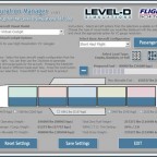
In the climb I engage the auto-pilot and settle in to explore the aircraft a bit. Experimenting with the FMS pages I find the PROGRESS page that shows a convenient summary of how the flight is progressing. It summarizes the distance and ETA to the next two flight-planned waypoints, the fuel remaining at each, suggested Mach number at altitude and further suggestions for a climb to a more fuel efficient altitude.

Approaching Charleston VOR (HVQ) the flight director and autopilot smoothly anticipate the turn to remain on course on the other side of the fix with the white turn predictor line arcing around to match the FMS plotted turn. I sip my coffee (no Bailey’s thank-you) and marvel at how HAL 9000 flies so precisely.

Continuing with my explorations I find a button on the panel that places the FMS derived ETAs on the EHSI map. That would be useful for making non-radar compulsory position reports! I’ve also manually entered the VOR frequencies into the VOR selectors on the eyebrow panel so that I can watch the RMI/DME track our progress. The auto-throttles are maintaining a steady Mach .782 and with the 63 knot winds displayed out of the south-west we are cooking across the ground at a respectable 529 knots.

The second page of the PROGRESS page breaks down the winds aloft, cross-track error, true-airspeed, temperature, fuel flows and fuel consumed.

Yet another page displays the recommended economy setting for the current cruise altitude (FL250 which I know is not an ideal altitude for the 767), the optimum altitude at our weight (FL309), and the maximum attainable at our current (heavy) weight (FL362). Obviously as the flight progresses and fuel is burned the gross weight changes and these numbers are in constant flux (generally trending toward higher altitudes as weight is reduced).

The LEGS page allows me to set in vertical navigation (VNAV) data so that I can plan my descent to make crossing restrictions and speeds on the arrival into Boston. I’ve programmed in crossing JFK VOR at FL180 and 300 knots with subsequent crossing restrictions on the next pages.

Related Posts:
Related posts:
 Boeing vs. Airbus – Part 1 Simulation Software Workshop Airbus A310 Page 5
 Boeing vs. Airbus – Part 2 Level-D Simulations Boeing 767
 Page 2
Boeing vs. Airbus – Part 2 Level-D Simulations Boeing 767 Page 3
Boeing vs. Airbus – Part 2 Level-D Simulations Boeing 767 Page 4
Boeing vs. Airbus – Part 2 Level-D Simulations Boeing 767 Page 6
Boeing vs. Airbus – Part 2 Level-D Simulations Boeing 767 Page 7
Boeing vs. Airbus – Part 2 Level-D Simulations Boeing 767 Page 8
Boeing vs. Airbus – Part 2 Level-D Simulations Boeing 767
Boeing vs. Airbus – Part 2 Level-D Simulations Boeing 767 Page 2
Boeing vs. Airbus – Part 2 Level-D Simulations Boeing 767 Page 3
Boeing vs. Airbus – Part 2 Level-D Simulations Boeing 767 Page 4
Boeing vs. Airbus – Part 2 Level-D Simulations Boeing 767 Page 6
Boeing vs. Airbus – Part 2 Level-D Simulations Boeing 767 Page 7
Boeing vs. Airbus – Part 2 Level-D Simulations Boeing 767 Page 8