SimHQ: Why Slovakia?
Juraj: We are Slovaks and there was a lot of action in the air towards the end of WWII over Slovakia. At the end, who wouldn’t want to fly over his own country?
Martin: Plus we believe that Slovakia features some unique and diverse landscape that could be fun to fly / fight over — from large flat fields in the south to narrow valleys and mountains in the north.
SimHQ: Which aircrafts in the simulation “match the map” for each phase of the war?
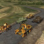
Juraj: For the short Hungarian-Slovak conflict from March 1939 there are none — neither Avia B-534, Letov S-328, Ju-86, nor Fiat CR-32 is available. For the Slovak National Uprising and 1944/45 period, there were probably all aircraft types from Eastern front involved, including American P-51s, B-17s, B-24s, P-38s and even British Mosquitoes. The types which were using the map’s historical airfields are plentiful — Slovak and German Bf 109, “Jabo” Fw 190, night Bf-110, He-111, Ju-87, Ju-88, Fw-189, La-5FN, IL-2, Pe-2, B-25, Li-2. The operation of the rather big insurgent air force during the Slovak National Uprising inside the enemy territory for almost two months is unique in WWII history.
Martin: And we can always fly those 1946 jets over Slovakia too. ![]()
Peter: It must be mentioned that the aerial activity over Slovakia in WWII started with air raids of 15thn USAAF in late spring 1944. The encounters had intensified during the Slovak National Uprising and during the liberation of our territory by Red Army in 1944/45.
SimHQ: It took a very long time to build the map. What were the biggest challenges?
 Juraj: The most important feature (at least in my eyes) was the elevation model. The map area covers the altitude range from 150m lowlands to >2600m peaks of High Tatra mountains. “Indy” is luckily a geologist by occupation and in the very beginning he provided the altitude map in black-and-white scale so we had solid material to start with. After first excitement, I found I have to adjust the altitude model in the map tool pixel-by-pixel manually, since the original map was still too crude for my taste — like these peaks are too blunt, this small hill is missing completely, and where is that deep valley behind our village? For the major part of the manual adjustment of the altitude map we used Google Earth as a visual aid. Only this process took 9 months. To the end we learnt there are much better SRTM satellite data available, but it was too late. Object modeling itself took 10 months, only to get the roads and railway tracks right and on flat surface it took weeks. Textures were being worked on and improved during the whole process. Finally, the object pattern creation and manual customization of the major cities, industrial areas and castle ruins took half year. However, we were doing this besides our work and trying not to break our families so our time was also limited.
Martin: From my perspective, the biggest challenge was to get as many objects modeled as possible without compromising quality. I wish I could have done 50 more objects for my full satisfaction. ![]() Currently, the biggest challenge is to convince everyone (including both the map team members and our family members) to keep on working and survive the last remaining days in order to finish and test the map properly. And object placement is a real hell too.
Currently, the biggest challenge is to convince everyone (including both the map team members and our family members) to keep on working and survive the last remaining days in order to finish and test the map properly. And object placement is a real hell too.
SimHQ: How large is the map, and how do they compare to others in the simulation?
Juraj: Its size (including the 2km flat border) is 224 x 136 km. It is size-wise similar to Crimea map and contains 12 times more area than for example 50 x 50km Ardennes. To fly it diagonally at 360kph TAS, it takes 44 minutes.
SimHQ: What are the unique features of the map (terrain, buildings, textures)?
 Juraj: The map terrain is very precisely done considering the IL-2 technology limitations. Often there is a view open in front of me I know from my hiking or mountain bike trips in the mountains. There are high-positioned lakes (remnants from the Ice age) in the High Tatra Mountains — about 30 of them. There are also several water dams in Stiavnicke vrchy mountain area, built in 17th century for collecting the water which powered the mining machines.
A few textures are based on standard IL-2 textures but most of them are completely new. To get the textures look believable and compatible with each other, it is a very hard job and without our graphic guru “Rik” the map would not be half as good looking as it is now.
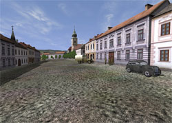
Martin: As I have mentioned before, the map features up to 50 unique castles or castle ruins. In addition, all cities, towns and hundreds of villages are more-or-less handmade according to historical photos and their real layouts during the war. There are several big factories and one oil refinery, modeled according to aerial photos taken by B-24 bombers during their air raids. The map is fully customized all the way to its very edges. I dare say that a low flying pilot should spot something unique (landscape or objects) in less than every 5 minutes no matter what direction they fly. For me, it’s possible to navigate through the map by just recognizing the unique objects. Another feature that I don’t seem to recall from any other map in the IL-2 series is the ability of parallel take-offs from open hangars, and landings for both AI and human controlled airplanes. The open hangar will fit all airplanes up to the size of the B-25, He-111 or Ju-88. Three of our airbases allow such take-offs and landings. Please check our video to see this feature in action. Last but not least, there are about 20 Easter Eggs through out the map.

Cliffhangers
Related Posts:
Related posts:
 IL-2 Slovakia
 IL-2 Slovakia Map Team
 Page 2
IL-2 Slovakia Map Team Page 4
IL-2 Slovakia Map Team
IL-2 Slovakia Map Team Page 2
IL-2 Slovakia Map Team Page 4
 Tactical Briefing 03: Squad and Fire Team Movements Page 2
 Team Fusion Mod for IL-2 Sturmovik: Cliffs of Dover
 Page 3
Team Fusion Mod for IL-2 Sturmovik: Cliffs of Dover Page 4
Team Fusion Mod for IL-2 Sturmovik: Cliffs of Dover
Team Fusion Mod for IL-2 Sturmovik: Cliffs of Dover Page 3
Team Fusion Mod for IL-2 Sturmovik: Cliffs of Dover Page 4